Zach, our GIS Analyst intern, has been with us since the beginning of April. He just finished his junior year at UW, where he is majoring in Geography with a GIS track.
We thought we would check in with him and see how his internship is going:
What made you want to intern at SpatialDev?
I was initially looking for any GIS internship out there. But when I found out about the SpatialDev internship, I applied and started looking at what SpatialDev is about and what they do.
It seemed like a friendly place that has that start-up-y feel to it, which was an important criterion for me. I actually asked about the culture and environment in my phone interview because it really was important to me.
After chatting with some team members, it felt like I would be doing real work and not just fetching coffee; that was important as well. Overall, it seemed like a good place to hone my skills as a GIS analyst, which is what I’m hoping to do as a career.
Is this your first internship in this field? If not, how is it different from your other internships?
I never had an internship within the geography/GIS field. To be honest, I only recently picked geography as my major. I initially wanted to do computer science. I took an intro GIS class. I didn’t know anything about it but loved the class and chose that as my major and it felt natural.
This is exactly the internship I wanted: I needed something that was going to develop my GIS skills in a relaxed, fun environment, and with a flexible schedule that would accommodate my classes. I felt that everybody at the office always respected my school hours and made sure that was a priority.
Are you learning new things that you didn’t know of from your classes?
In class, we learned a lot of abstract concepts about GIS. They spent a lot of time explaining what makes a good map, how to present a map, and about different types of maps. Here at SpatialDev, those abstract concepts became more real. We also learned about only one software (ArcMap) in class. At SpatialDev, I’ve learned 3-4 other software tools (GIS and database management) and frameworks that I will surely use in the future. Overall, I have learned more GIS-related things in this internship than in all my classes over two quarters.
Anything exciting that you didn’t expect to learn?
I had high expectations going into this internship and I was hoping to work on real projects. I’m glad to say that’s happening. For example: My first week here, I expected to start slow with orientation and onboarding, but Phoebe (a UW alum) got me going right off the bat on a real project which aimed to find the best location for an orange processing plant in Tanzania using GIS analysis. Phoebe had done a lot of the base work needed to bring in the data, but we worked together to develop a formula to support the request. I feel like I played an integral part in problem solving for that project, all within my first week here!
When people ask me about this internship, that’s the project I use to explain what I do.
How do you describe what you do for a living to your friends?
I usually describe what I do with examples rather than an abstract description. I use examples like the orange-processing project or FSP (Financial Services for the Poor), and explain that my work is related to finding best location for different things.
What are you currently working on?
Right now I’m working on FSP (Financial Services for the Poor), which involves mapping financial service points in Sub-Saharan Africa. I’m making maps for the different country sectors and showing accessibility to those points. The app will be presented by our client in Uganda next week, so we are hard at work to finish that up.
What are you geeking out about right now?
I’m a big hip hop fan – more so old school than new school (Tribe Called Quest is my favorite of all time). I also collect sneakers (old school Jordans, Nikes, high-top Vans) so you’ll find me geeking out on that.
What has been your favorite project/task so far at SpatialDev?
I still love the project I had my first week of my internship (orange processing in Tanzania). That was super fun to work on and challenging. But to be honest, in general, if I’m doing GIS stuff (as opposed to data inventory) I’m happy.
What music do you listen to at work? At home?
I listen to old school hip hop: Tribe, Snoop Dogg, Fugees, Wu Tang, De la Soul, Outkast, Biggy, Nas, 2pac, Jay-Z, Jurassic 5, Kanye West, Kendrick Lamar, Common. I can keep going…
What’s one GIS tip or trick that you use in your work?
Rene taught me to use GDAL framework, which is just like terminal commands for terminal commands functions, so instead of using ArcMap or QGIS, I use GDAL because it’s much faster. It’s a huge time-saver.
If there is one thing you would like people to know about GIS, what would it be?
First of all, I would like people to know what GIS is! And I want people to understand that GIS can be used in all fields of work. Anybody with data and anybody with physical assets (like buildings or servers) can use GIS to benefit themselves.
Any fun or quirky fact we should know about you here at SpatialDev?
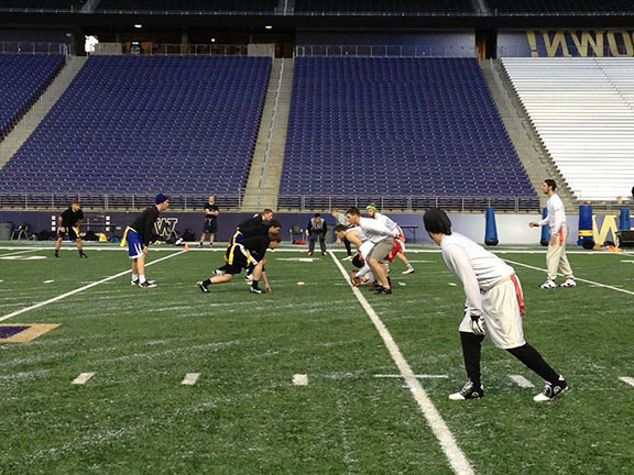
I’m an intramural flag football champion! At UW, there is an intramural football league; I’m in it, and we won the championship this year! I played quarterback and won all 10 games! I’m looking forward to the next season starting in the Fall. That’s probably one of my favorite things about college.


